Frozen pipes, frostbite and hypothermia were all possible as part of the dangerous, extreme cold set to hit the entire Chicago area Friday, the National Weather Service warned, and some parts of northeastern Illinois will have it worse than others.
The Arctic front, set to arrive late Thursday and into Friday morning led the NWS to upgrade its extreme cold watch to a warning, with wind chills ranging from -20 to -40.
“Cover everything. All exposed skin,” NBC 5 Storm Team Meteorologist Alicia Roman warned. “Because it will be very, very dangerous to be out there.”
Friday’s forecast is likely to break records, with Chicago expected to see its coldest day in years. More than a dozen Illinois schools have already announced they’ll be closed or doing e-learning due to the brutal temperatures.
As the cold approaches, here’s a look at what parts of the Chicago area will feel the coldest, when the temperatures will be at their worst and more.
Here’s which parts of Chicago will be the coldest
While Thursday afternoon will see highs in the 20s, a sharp drop in temperatures and wind chills will come overnight, Roman said, starting at about midnight.
At 3 a.m., an extreme cold warning for all of northeastern Illinois and parts of southeastern Wisconsin will go into effect.
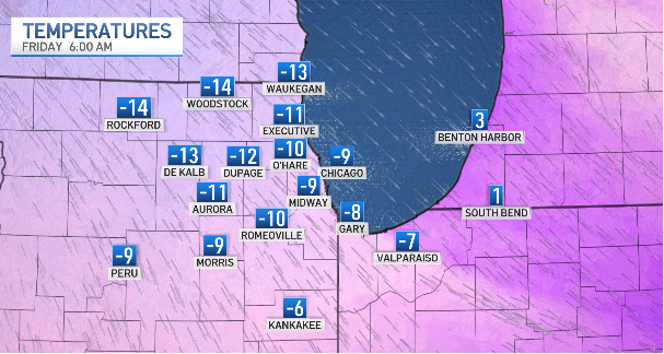
At that time, air temperatures in Chicago are expected to be about -10 degrees. In counties to the south and in northwest Indiana, they may be slightly warmer, at about -6 degrees.
In counties to the north and west, it’ll be colder, with air temperatures in the negative teens, the NBC 5 Storm Team said. Wind chill values will be even worse, especially in parts north and west of I-55, the NWS warned.
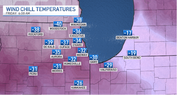
Friday morning in Woodstock, the predicted “feels-like” temperature was -40 degrees. The temperature was expected to feel like -39 in DeKalb, -37 in DuPage, and -38 in Waukegan.
In parts southeast of I-55, and in northwest Indiana, wind chills would range from -20 to -30.
The worst of the cold was expected to last through 12 p.m. Friday, though the afternoon wouldn’t be much better, Roman said, with a high of -2 degrees.
“Some areas will likely see actual temps remain below zero all day,” the NWS said.
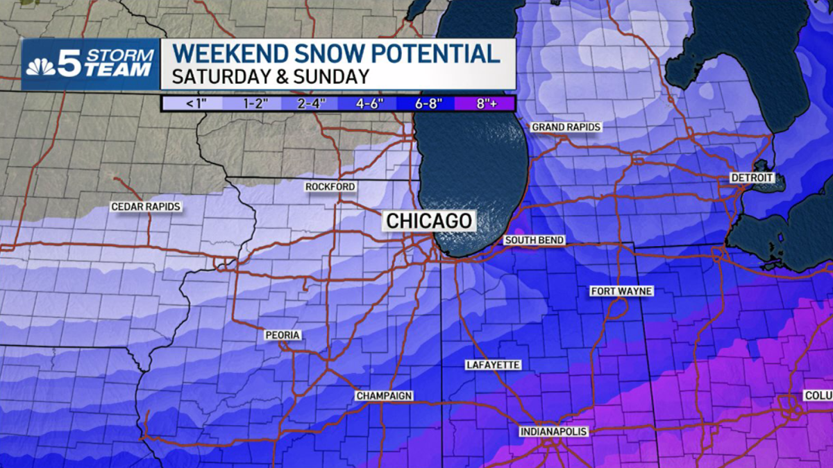
Saturday, the high temperature was 11 degrees, and Sunday, the predicted high was 18, with snow chances both days as a major winter storm makes its way across the country.
This story uses functionality that may not work in our app. Click here to open the story in your web browser.