

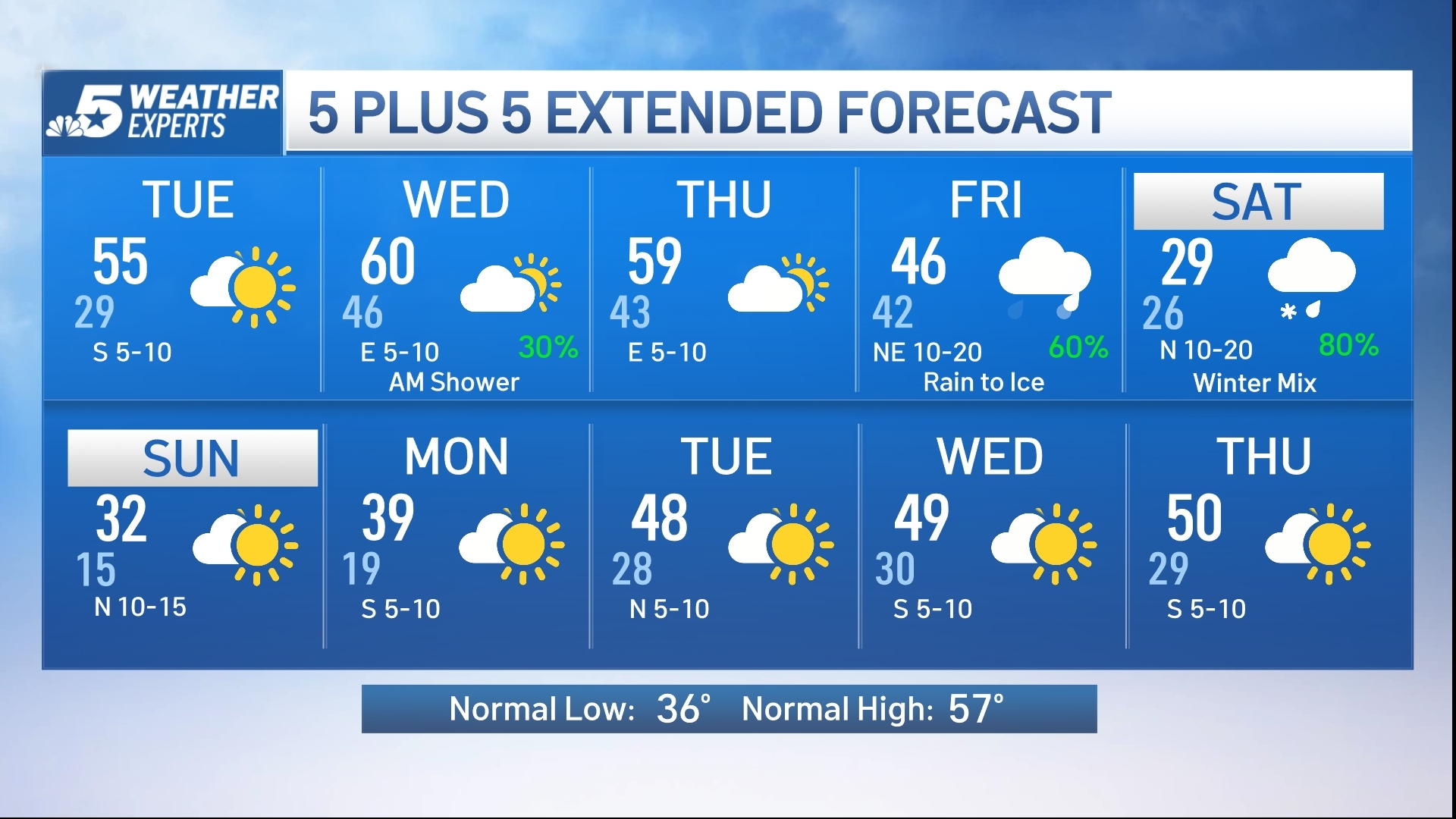
An Arctic air mass is expected to arrive in North Texas on Friday and last through Sunday morning. The time to start preparations for what is expected to be a “very impactful winter storm” is now.
NBC 5’s Chief Meteorologist Rick Mitchell said forecasters expect the storm to bring moderate to heavy accumulations of snow, sleet and ice. Travel is expected to be hazardous, and power outages are possible.
Friday will feature an Arctic cold front moving into North Texas. Precipitation will start as cold rain, persisting into the early evening.
As temperatures fall below freezing, this cold rain will transition to a wintry mix (freezing rain and sleet) by Friday night.

This winter mix (freezing rain, sleet and snow) will last into Sunday morning with temperatures only in the 20s. Low temperatures are likely to bottom out in the teens for Sunday and Monday mornings.
While it is still early, this winter storm has the potential to be quite impactful on roads and travel late Friday into Monday morning.
Make sure you stay up to date on the forecast through the week.
Forecasters warn of a ‘potentially catastrophic’ storm from Texas to the Carolinas
With many Americans still recovering from multiple blasts of snow and unrelenting freezing temperatures in the nation’s northern tier, a new storm is set to emerge this weekend that could coat roads, trees and power lines with devastating ice across a wide expanse of the South.
The storm arriving late this week and into the weekend is shaping up to be a “widespread potentially catastrophic event from Texas to the Carolinas,” said Ryan Maue, a former chief scientist at the National Oceanic and Atmospheric Administration.
“I don’t know how people are going to deal with it,” he said.
Forecasters on Tuesday warned that the ice could weigh down trees and power lines, triggering widespread outages.
“If you get a half of an inch of ice — or heaven forbid an inch of ice — that could be catastrophic,” said Keith Avery, CEO of the Newberry Electric Cooperative in South Carolina.
The National Weather Service warned of “great swaths of heavy snow, sleet, and treacherous freezing rain” starting Friday in much of the nation’s midsection and then shifting toward the East Coast through Sunday.
Temperatures will be slow to warm in many areas, meaning ice that forms on roads and sidewalks might stick around, forecasters say.
The exact timing of the approaching storm — and where it is headed — remained uncertain on Tuesday. Forecasters say it can be challenging to predict precisely which areas could see rain and which ones could be punished with ice.
Here’s what to know:
Cold air clashing with rain to fuel a ‘major winter storm’
An extremely cold Arctic air mass is set to dive south from Canada, setting up a clash with the cold temperatures and rain streaming eastward across the southern U.S.
“This is extreme, even for this being the peak of winter,” National Weather Service meteorologist Bryan Jackson said of the cold temperatures.
When the cold air meets the rain, the likely result will be “a major winter storm with very impactful weather, with all the moisture coming up from the Gulf and encountering all this particularly cold air that’s spilling in,” Jackson said.
An atmospheric river could set up across the southern U.S.
An atmospheric river of moisture could be in place by the weekend, pulling precipitation across Texas and other states along the Gulf Coast and continuing across Georgia and the Carolinas, forecasters said.
“Global models are painting a concerning picture of what this weekend could look like, with an increasingly strong signal for ice storm potential across North Georgia and portions of central Georgia,” according to the National Weather Service’s Atlanta office.
If significant accumulations of ice strike metro Atlanta, it could be a problem through the weekend since low temperatures early Monday are expected to be around 22 degrees (minus 5.6 Celsius) in Atlanta. The city’s high temperature on Monday is forecast to be around 35 degrees (1.7 Celsius).
Highway and air travel could be tangled by the storm
Travel is a major concern, as southern states have less equipment to remove snow and ice from roads, and extremely cold temperatures expected after the storm could prevent ice from melting for several days. In Michigan, more than 100 vehicles crashed into each other or slid off an interstate southwest of Grand Rapids on Monday.
The storm is also expected to impact many of the nation’s major hub airports, including those in Dallas, Atlanta, Memphis, Tennessee, and Charlotte, North Carolina.
Polar air from Canada to keep northern states in a deep freeze
Unusually cold temperatures are already in place across much of the northern tier of the U.S., but the blast of arctic air expected later this week is “will be the coldest yet,” Jackson said.
“There’s a large sprawling vortex of low pressure centered over Hudson Bay,” Jackson said of the sea in northern Canada that’s connected to the Arctic Ocean. “And this is dominating the weather over all of North America.”
Texas could be a harbinger for other parts of the South
Some of the storm’s earliest impacts could be in Texas on Friday, as the arctic air mass slides south through much of the state, National Weather Service forecaster Sam Shamburger said in a briefing on the storm.
“At the same time, we’re expecting rain to move into much of the state,” Shamburger said.
Low temperatures could fall into the 20s or even the teens in parts of Texas by Saturday, with the potential for a wintry mix of weather in the northern part of the state.
Forecasters cautioned that significant uncertainty remains, particularly over how much ice or snow could fall across north and central Texas.
“It’s going to be a very difficult forecast,” Shamburger said.


COLD WEATHER PREPARATION

Winterizing Your Home
Before the cold, replace worn weatherstripping on doors and windows to ensure a good seal. This will make sure warm air stays inside and cold air stays outside. Most modern windows are sealed inside the frame, but older windows may be sealed with a glaze that can crack and need replacing. The glaze may need to be applied above a certain temperature and it’ll need time to cure — this maintenance is ideally done in the spring or fall. Lastly, check your gutters to ensure they are clear and allow water to flow freely to the downspout. Blocked gutters can lead to water entering the home. The Texas Department of Insurance also recommends trimming trees away from power lines, homes, and cars and checking the insulation level in attics.
Protecting Your Pipes
Most North Texans know to insulate their outdoor faucets, but if the cold snap is prolonged it could be a good idea to also leave inside faucets on external walls dripping overnight so that they don’t freeze. The drip, drip, drip from running faucets, if heard, can be annoying, so put a sponge or towel in the sink to silently catch each drop. If you’re leaving town for a few days, the Texas Department of Insurance recommends leaving cabinet doors open so that pipes on external walls are more exposed to heat. If you have pipes in an attic or crawlspace or any other exposed pipes outdoors, they’ll need insulation, too. For external faucets, disconnect hoses and insulate the valves. Wrapping valves with towels is not the best long-term solution. Most, if not all, North Texas hardware stores sell inexpensive exterior faucet covers made of foam that easily attach to the faucet bib in just a few seconds and do a great job protecting the pipe from freezing. If you suspect a pipe has frozen, keep the faucet open so that water can flow when it melts. Additionally, make sure you know where your main water valve is located (and how to turn it off) in the event a pipe bursts.

Bring in Your Pets
Even if you have a pet or animal that normally lives or sleeps outdoors, they could be susceptible to cold, hypothermia, and pneumonia. The SPCA of Texas says if you’re cold outside, odds are your pet is cold too. Bring pets inside and make sure other outdoor animals have appropriate shelter, dry and well insulated, to protect them from frigid temperatures and possible death.
Protecting Your Plants
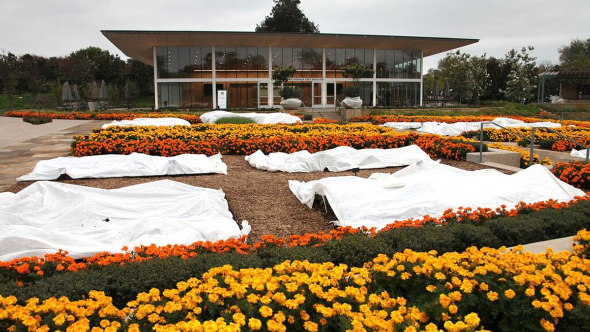
Perennial potted plants should be brought indoors. Plants that cannot be brought inside will need to be covered. Delicate plants can be covered with sheets, blankets, or landscaping frost blankets, which can trap heat. During times of extreme cold, multiple frost blankets may be used. For plants left outside a day or two before a freeze hits, the Dallas Arboretum recommends watering the soil only by hand, keeping the foliage dry to insulate the plant’s roots. The Texas A&M AgriLife Extension has more here on how to protect plants from frosts and freezes. AgriLife also has tips on how to plant for the winter.
Turn Off Your Sprinkler System
You want to turn off your irrigation system for several reasons. One is that you don’t want it running on its normal schedule, potentially throwing water on streets where it can freeze and be dangerous for passing cars. Second, you don’t want to risk any broken pipes or valves that may come with a system that has not been winterized. To winterize your system, the city of Fort Worth recommends that timers and back-flow devices both be turned off, even if you have freeze or rain sensors installed and that the main line be drained. Any pipes that are above the ground should also be insulated.
HVAC
Many air filters should be changed or cleaned every three months or every season. But that’s not the only winterizing needed for your HVAC system. You should check your ductwork regularly for holes (whether from vibration or rodents) to ensure the airflow is uninterrupted. If part of your HVAC is in the attic, it may also be home to rats, mice, and squirrels who find the unit’s warmth an ideal spot to build a nest.
Swimming Pools
Even if you have a freeze protector among your pool equipment, you’ll want to look at the pump daily to ensure it’s moving water through your pipes. Those pipes, too, can burst if they freeze.
Batteries
Having fresh batteries for flashlights during a power outage is always a good idea. If you didn’t replace the batteries in your smoke and carbon monoxide detectors during daylight saving time — now is a good time to make the switch. It’s also a good idea to ensure your phone is charged so that you’ll have access to timely information in the event of a power loss. Having a backup battery or power source to recharge your phone is also a good idea.
This story uses functionality that may not work in our app. Click here to open the story in your web browser.


