

What to Know
- Temperatures will plummet as Arctic air moves in late Friday, and subzero wind chills will grip the D.C. area on Saturday morning.
- Snow arrives late Saturday, and you’ll likely wake up Sunday to several inches on the ground.
- Ice is a growing concern. If there’s significant freezing rain later Sunday, it could lead to power outages.
- Storm Team4 declared a weather alert for one of the most serious snow threats the D.C. area has seen in years.
- Download our apps to keep up with the forecast.
A winter storm is set to dump 6-10+ inches of snow plus ice in the Washington, D.C., area as bone-chilling cold grips the region. Treacherous travel conditions are expected Sunday and possibly into early next week, and there’s growing concern about ice triggering power outages.
Snow is likely to arrive on Saturday evening and continue coming down on Sunday. A winter storm warning was issued for the D.C. area; it’s set to be in effect from 11 p.m. Saturday to 4 a.m. Monday. There’s also a cold weather advisory.
Arctic air is set to move in late Friday, and we expect temps near 10° by Saturday morning with wind chills below 0°. The shocking cold sets the stage for a high-impact winter storm as D.C.-area residents rush to grocery stores and crews pretreat roads.
Leaders in D.C. and Virginia declared states of emergency and Maryland Gov. Wes Moore announced a “state of preparedness” to get agencies mobilized and ready to respond to the weather.
D.C. Mayor Muriel Bowser said she requested the National Guard to assist. Troops are already in the city, deployed by President Donald Trump.
School closures are likely on Monday, and delays and closings are possible later in the week, too.
Snow totals map
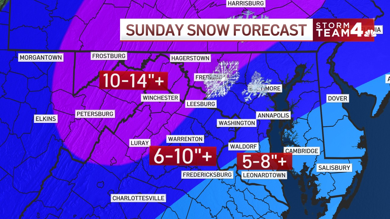
How much snow to expect
There should be a solid 3-6 inches of snow by Sunday morning, and snow will likely continue to fall into early Sunday afternoon.
The storm will dump 6-10+ inches of snow near the Beltway, with higher amounts possible north and west of Dulles International Airport, in areas including Frederick, Maryland, and Leesburg, Virginia. That’s where 10 to 14 inches of snow is possible.
Plan to shovel multiple times.
Here’s a closer look at what to expect zone by zone:
D.C. metro area: Snow is expected to arrive about 10 p.m. Saturday. Expect snow Sunday morning, then sleet mixing in by noon. Freezing drizzle is possible before the storm moves out, but the latest information shows it’s not a major concern.
Southern zone, including Southern Maryland, Northern Neck of Virginia, Fredericksburg, parts of King George and Spotsylvania counties: Snow will turn to sleet and freezing rain. Expect dangerous driving conditions and power outages.
Western zone, including Frederick, Maryland, and Leesburg and Warrenton, Virginia: Snow starts Saturday evening. Expect heavy snow through midday Sunday. Some sleet is likely, but these areas will have higher snow totals. Avoid travel.
Mountain zone, including Hagerstown, Winchester and Luray: These areas will likely have the highest snowfall totals, with heavy snow falling from late Saturday into Sunday. There’s a still a chance for some sleet.
Freezing rain is a growing concern
How much snow you get depends on how soon our winter storm starts dropping ice instead of flakes. This is the most critical part of the forecast.
Not all ice is the same. Freezing rain is a much bigger concern because it can bring down trees and lead to widespread power outages.
“I’m very worried about power outages in southern Maryland, also in parts of Northern Virginia. The farther south you go, the more chances you have for freezing rain,” Storm Team4 chief meteorologist Doug Kammerer said.
We’d much rather have sleet. The small, clear ice pellets bounce and can actually add traction to roads and sidewalks.
Closer to D.C., sleet and freezing rain are both possible, but we’re expecting more sleet. However, it’s still early to fine-tune predictions about ice.


Stay with Storm Team4 for updates, and make sure you’re prepared.
- Charge electronic devices and put fresh batteries in flashlights.
- Stock up on essentials, including prescriptions, and make sure emergency supplies are easy to find.
- Top off your gas tank or charge your electric car.
- Seal your home from air leaks.
- Use space heaters cautiously – keep them far away from anything flammable and don’t leave them unattended.
What about travel and road conditions?
During the day on Saturday, you won’t have any travel troubles. It will be bitterly cold, so make sure you wear plenty of warm winter gear.
Roads will be snow-covered on Sunday, and it will likely be the worst day to travel. A couple of inches of ice could fall, as well.
By midday Monday, interstates and main roads should be cleared, but neighborhood and side roads might be a mess until Tuesday or even longer.
School closures and delays will be possible on Monday, and possibly later in the week, too.
This winter storm is expected to affect millions of people across much of the United States. Major airlines are letting people change their travel plans ahead of the storm, NBC News reports.
Once the storm passes, winter won’t be done with us yet. The D.C. area could see a record-breaking cold stretch.
Be prepared for your day and week ahead. Sign up for our weather newsletter.


