

What to Know
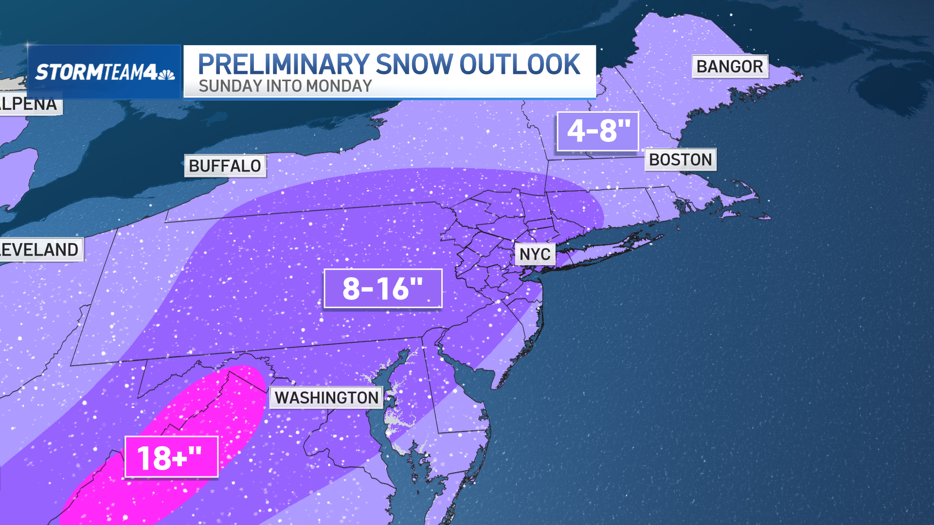
- Preliminary forecasts show 8-16 inches of snow can be expected for much of the region, including New York City, the Hudson Valley, nearly all of New Jersey and into Connecticut; areas along the coast may see slightly lower totals,
- Winter storm watches are up for the tri-state area. The forecast hinges on the track of the low-pressure system and the resulting temperature profile in the atmosphere. The picture will become clearer as we get closer to the event.
- The Northeast will get hit hardest Sunday afternoon and evening, with residual light snow Monday. Be prepared for travel to remain very difficult Monday morning and expect school, business, and government office closures on Monday, too.
- Extreme cold is expected to linger for at least a week after the storm moves out.
A monster winter storm is expected to sweep across much of the U.S. through this weekend, dumping up to 16 inches of snow onto the New York City area and unleashing absolute havoc across the country, as areas unaccustomed to snow stare at one of the most intimidating forecasts in some time.
It’ll also be one of the biggest snowstorms for New York City in recent years. The last time Central Park saw over 12 inches was in early February 2021, when over 17 inches fell.
Winter storm watches have now been issued for virtually the entire tri-state area. Check the latest severe weather alerts here.
As of Thursday morning, a widespread 8 to 16 inches of snow can be expected for much of the region, including New York City, the Hudson Valley, nearly all of New Jersey and into Connecticut. Areas along the coast may see slightly lower totals, thanks to snow mixing with sleet and freezing rain at times during the storm event.
In New York City, Mayor Zohran Mamdani, facing the biggest test of his administration to date, says the city is preparing for anywhere from 3 to 12 inches of snow. Citywide pre-snow treatment starts Friday to mitigate snow and ice impacts. Two thousand sanitation workers start 12-hour shifts on Saturday.
Mamdani said 700 salt spreaders will be out, hitting every city street, and pledged snow plowing will begin as soon as there is plowable snow. A Code Blue remains in effect for the cold, with outreach teams connecting with the most vulnerable.
Storylines to watch for this weekend’s snow
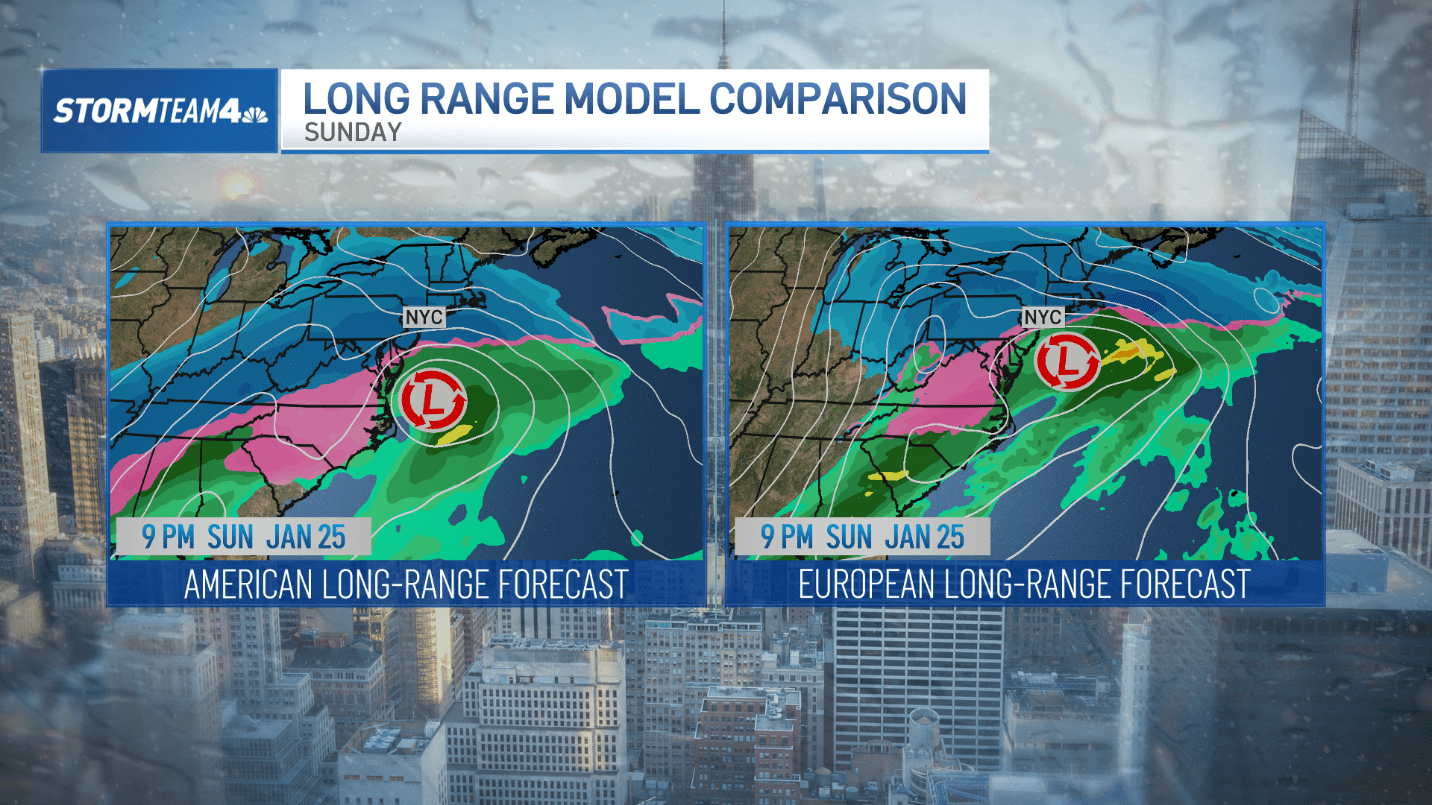
Are we set in stone here? Hardly. Expect changes to the snow forecast in the coming days. The forecast hinges on the track of the low-pressure system and the resulting temperature profile in the atmosphere. The picture will become clearer as we get closer to the event.
The current forecast calls for many hours of fluffy snow falling in the tri-state starting early Sunday and lasting perhaps into early Monday.
South of the heaviest snow areas, a band of sleet and freezing rain is expected to set up, which will make travel a nightmare Sunday night into Monday morning. Similarly to the snow, it’s too early to call exactly where that band of ice will develop, but at this point, the I-95 corridor through South Jersey, the Delmarva Peninsula Washington D.C., Virginia and North Carolina are places to avoid Sunday and Monday.
More coverage

Either way, this will be a large-scale, high-impact event for much of the country, even in the South, with significant snow and ice potential. Huge travel impacts and extensive power outages could occur.
Winter storm watches and warnings are in place stretching from Arizona to West Virginia. A number of New Jersey counties are already under a winter storm watch, and the rest of the East Coast is expected to see weather alerts added over the next day or so. Check severe weather alerts here.
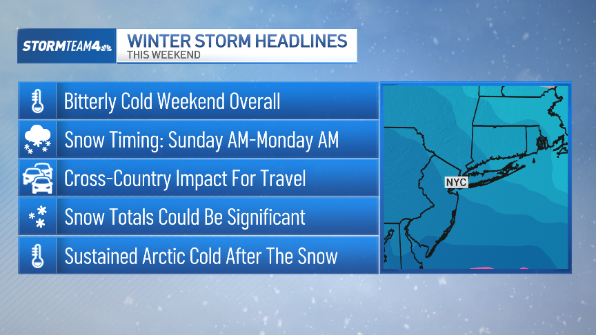
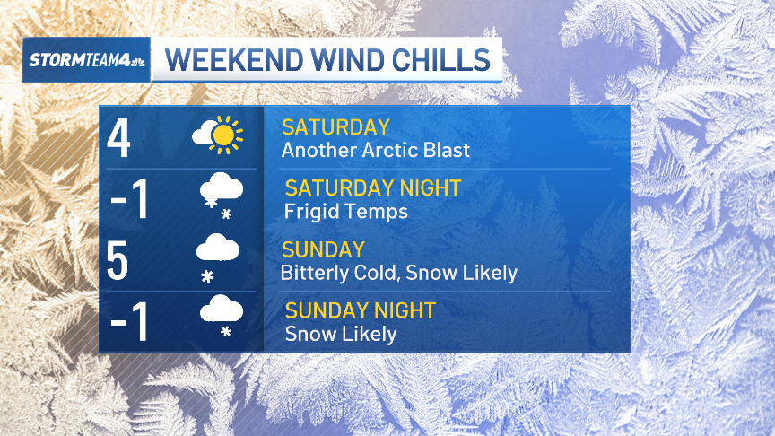
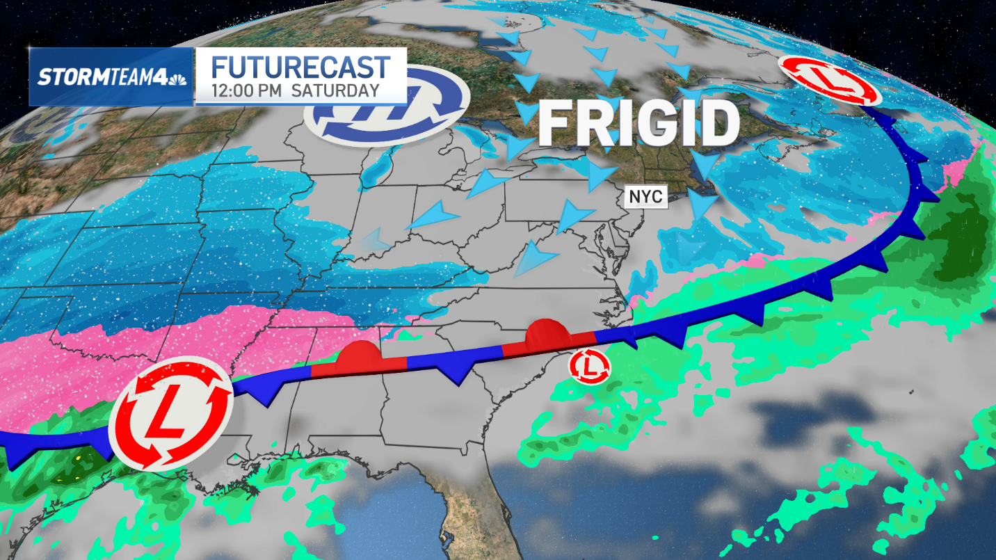
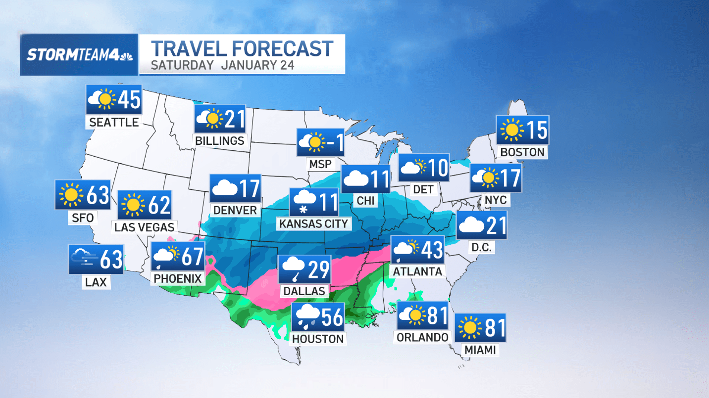
Before the snow arrives, expect another Arctic blast heading into the weekend. After a warmup on Thursday, the bitter cold moves back into the tri-state Friday night, setting the stage for the big snow potential.
Wind chills in the single digits can be expected Saturday and Sunday, and it could even feel below zero each night.
The storm track and snow forecast will come into better focus as we get closer to the event and more accurate atmospheric data is available. Until then, here are some things the tri-state area should know about the storm.
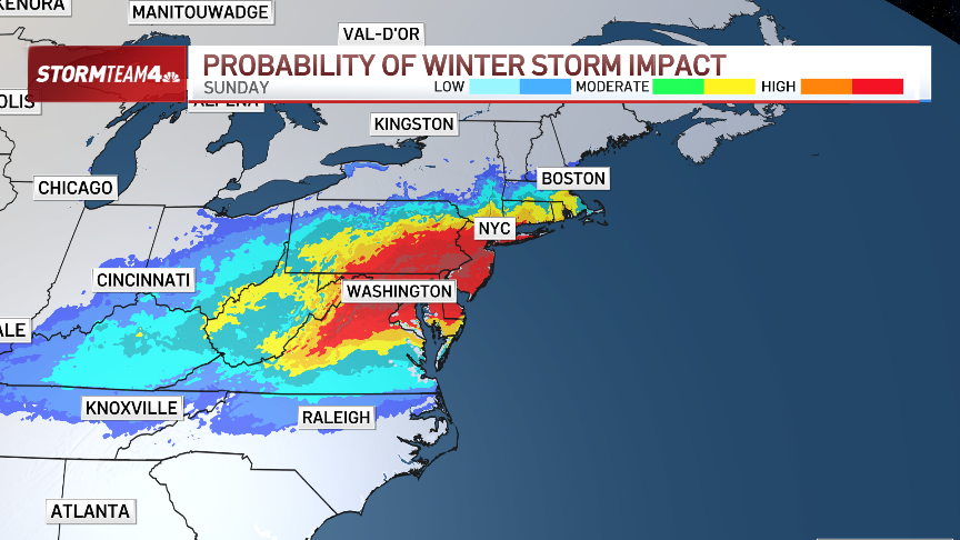
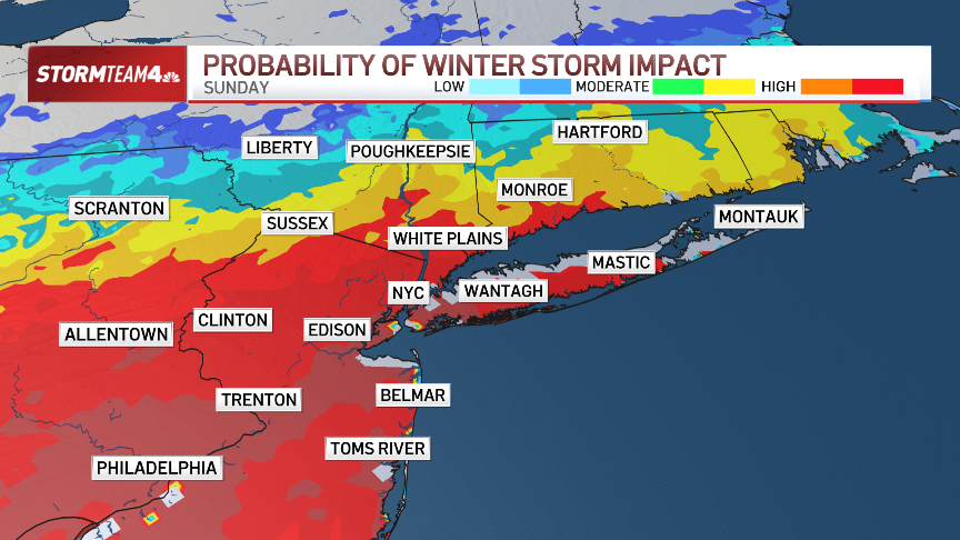
Sunday is the impact day for the East Coast
The storm will develop over Texas on Saturday, but the East Coast won’t feel a direct impact until Sunday. That’s when snow, sleet, freezing rain, and rain will impact everyone from New England to the Southeast.
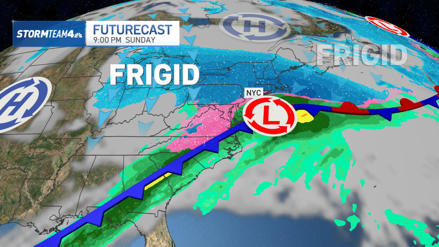
In the Northeast, the biggest impact is likely to be from the New York City metro area to the south.
Travel trouble starts Saturday
Weather on the East Coast will be quiet Saturday, but air travel will likely be a mess.
Snow and ice could grind airports to a halt in the middle of the country. Hubs like Dallas/Fort Worth, St. Louis, Memphis, Nashville, Cincinnati and possibly Atlanta will be impacted, and the ripple effect will cause delays and cancellations across the country.
Snow totals will be impressive for some
Once the storm makes it to the East Coast on Sunday, it will be a prolific snow-maker in certain regions – very possibly including the tri-state.
Snow totals will depend on the track of the storm and the precipitation type. Some areas will see all snow. That’s where over a foot of snow will be easy to get. Other places may see a mix of snow, sleet and freezing rain, which will significantly limit snow totals.
At this time, we can’t confidently pinpoint exactly where the heaviest snow will fall, but that picture will become clearer Thursday into Friday.
Ice could make travel treacherous
South of the heavy snow area, up to an inch and a half of ice could make driving on roads perilous. For now, those totals are expected to stay further south, in the Virginia area, but any shifts in the track of the storm could increase ice accumulation in New Jersey and around NYC.
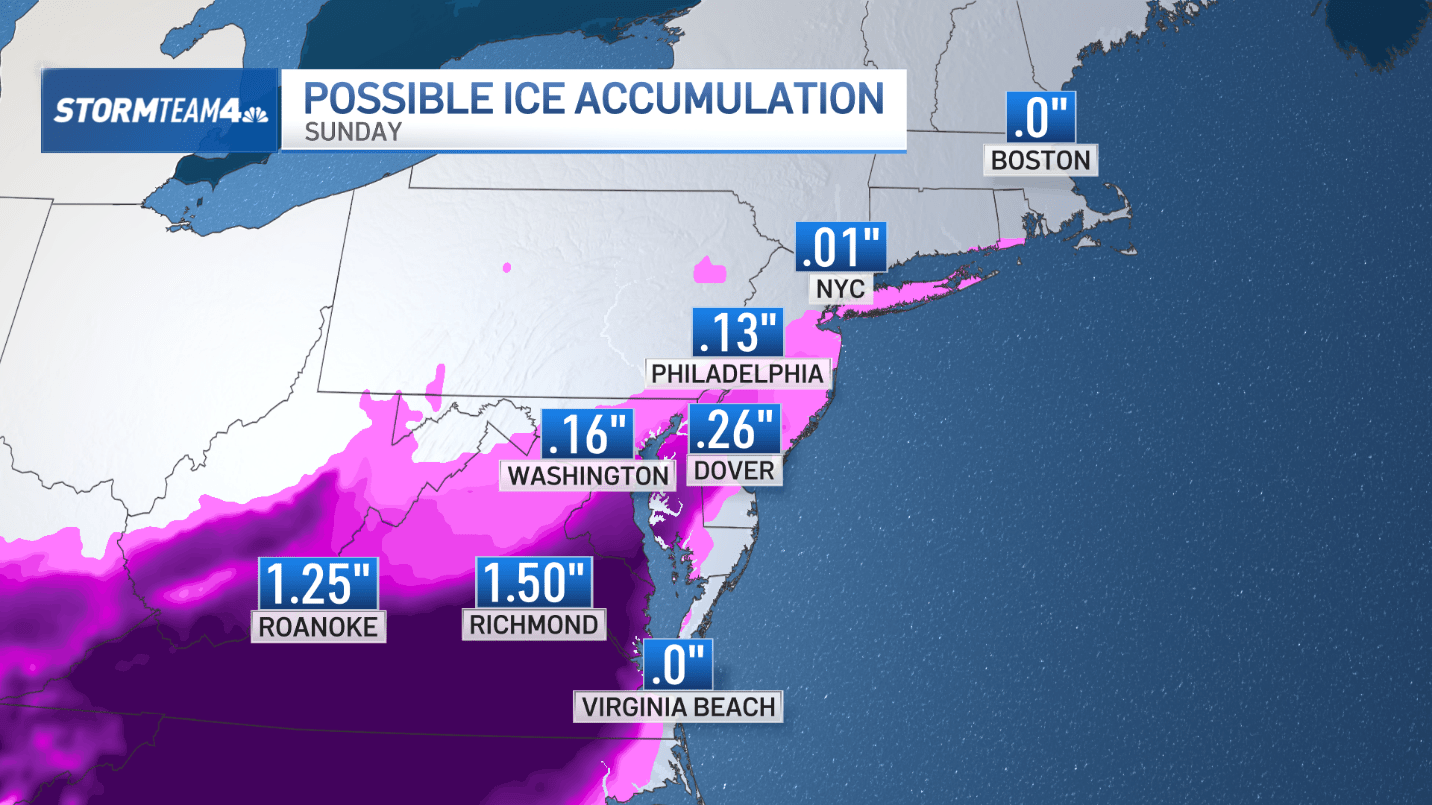
Further down the coast, we expect all rain due to warmer temperatures.
Expect Monday to be a mess
The Northeast will get hit hardest Sunday afternoon and evening, with residual light snow on Monday.
Be prepared for travel to remain very difficult Monday morning and expect school, business, and government office closures on Monday, too.
Track any approaching weather using our interactive radar below.
This story uses functionality that may not work in our app. Click here to open the story in your web browser.


